Geolocate

Brixham topographic map

Click on the map to display elevation.

About this map
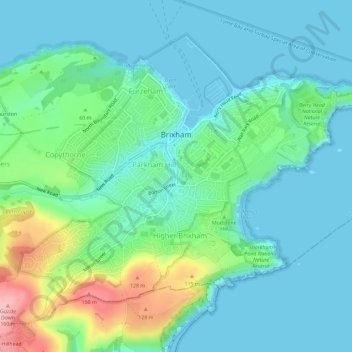
Name: Brixham topographic map, elevation, terrain.

Location: Brixham, Torbay, Devon and Torbay, England, United Kingdom (50.37597 -3.54037 50.40569 -3.48230)

Average elevation: 38 m

Minimum elevation: -1 m

Maximum elevation: 164 m

Other topographic maps

Click on a map to view its topography, its elevation and its terrain.
Torquay

United Kingdom > England > Torbay

Average elevation: 31 m

Paignton

United Kingdom > England > Torbay

Average elevation: 49 m

Galmpton

United Kingdom > England > Torbay

Average elevation: 57 m

Hope Cove

United Kingdom > England > Torbay > Torquay

Average elevation: 19 m

Maidencombe

United Kingdom > England > Torbay

Average elevation: 57 m

Corbyn Head

United Kingdom > England > Torbay > Torquay

Average elevation: 24 m

Tor Bay

United Kingdom > England > Torbay > Torquay

Average elevation: 0 m

Valley of Rocks

United Kingdom > England > Torbay > Torquay

Average elevation: 57 m

Torquay

United Kingdom > England > Torbay

Average elevation: 31 m

Paignton

United Kingdom > England > Torbay

Average elevation: 49 m

Torquay

United Kingdom > England > Torbay

Average elevation: 31 m

Hope Cove

United Kingdom > England > Torbay > Torquay

Average elevation: 19 m

Torquay

United Kingdom > England > Torbay

Average elevation: 31 m

Torquay

United Kingdom > England > Torbay

Average elevation: 31 m

Gear up for your next adventure:

🥤Hydration Packs - Hydration systems for hiking
📣High-Decibel Survival Whistles - Signaling tool for rescue that carries much further than a human voice
🦯Adjustable Trekking Poles - Reduce impact on knees when descending steep topographic ridges
📖Australian Bush Survival Books - Local knowledge on finding water and surviving the outback
🧥Thermal Emergency Blankets - Compact Mylar blankets to prevent hypothermia if stranded overnight

As an Amazon Associate, this site earns from qualifying purchases at no extra cost to you.