
Tirumayam topographic map
Interactive map
Click on the map to display elevation.
About this map
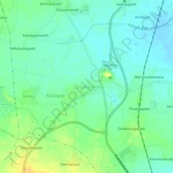
Name: Tirumayam topographic map, elevation, terrain.
Average elevation: 95 m
Minimum elevation: 85 m
Maximum elevation: 111 m
Other topographic maps
Click on a map to view its topography, its elevation and its terrain.
Ramachandrapuram (Kadiyapatti)
India > Tamil Nadu > Thirumayam taluk
Ramachandrapuram (Kadiyapatti), Thirumayam taluk, Pudukkottai District, Tamil Nadu, 622505, India
Average elevation: 84 m