
La Petite Rosière topographic map
Interactive map
Click on the map to display elevation.
About this map
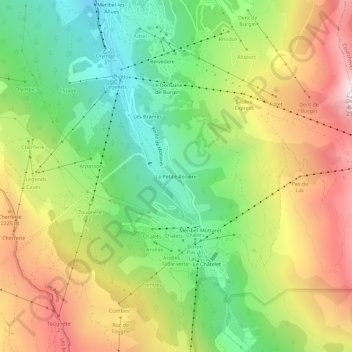
Name: La Petite Rosière topographic map, elevation, terrain.
Average elevation: 1,946 m
Minimum elevation: 1,391 m
Maximum elevation: 2,660 m
Other topographic maps
Click on a map to view its topography, its elevation and its terrain.
Le Châtelet
France > Auvergne-Rhône-Alpes > Savoie > Les Allues
Le Châtelet, Les Allues, Albertville, Savoie, Auvergne-Rhône-Alpes, France métropolitaine, 73550, France
Average elevation: 2,044 m