Geolocate

Basco topographic map

Interactive map

Click on the map to display elevation.

About this map

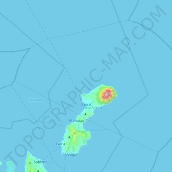
Name: Basco topographic map, elevation, terrain.

Location: Basco, Batanes, Cagayan Valley, 3900, Philippines (20.35347 121.81641 20.61556 122.18024)

Average elevation: 9 m

Minimum elevation: 0 m

Maximum elevation: 999 m

Other topographic maps

Click on a map to view its topography, its elevation and its terrain.

Itbayat Island

Philippines > Batanes > Itbayat

Itbayat Island, Itbayat, Batanes, Cagayan Valley, 3905, Philippines

Average elevation: 31 m

Itbayat

Philippines > Batanes

Itbayat, Batanes, Cagayan Valley, 3905, Philippines

Average elevation: 1 m

Batan Island

Philippines > Batanes > Mahatao

Batan Island, Mahatao, Batanes, Cagayan Valley, 3901, Philippines

Average elevation: 45 m

Padang

Philippines > Batanes

Padang, Sabtang, Batanes, Cagayan Valley, 3904, Philippines

Average elevation: 113 m