
Make a donation
Gear up for your next adventure:
As an Amazon Associate, this site earns from qualifying purchases at no extra cost to you.
Hastings District topographic map
Click on the map to display elevation.
Make a donation
Gear up for your next adventure:
As an Amazon Associate, this site earns from qualifying purchases at no extra cost to you.
About this map
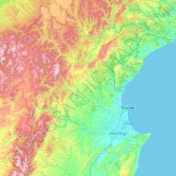
Name: Hastings District topographic map, elevation, terrain.
Location: Hastings District, Hawke's Bay, New Zealand (-39.89263 176.14273 -38.85596 177.09602)
Average elevation: 466 m
Minimum elevation: 0 m
Maximum elevation: 1,720 m
Make a donation
Gear up for your next adventure:
As an Amazon Associate, this site earns from qualifying purchases at no extra cost to you.
Other topographic maps
Click on a map to view its topography, its elevation and its terrain.
Make a donation
Gear up for your next adventure:
As an Amazon Associate, this site earns from qualifying purchases at no extra cost to you.
Make a donation
Gear up for your next adventure:
As an Amazon Associate, this site earns from qualifying purchases at no extra cost to you.
Make a donation
Gear up for your next adventure:
As an Amazon Associate, this site earns from qualifying purchases at no extra cost to you.
Make a donation
Gear up for your next adventure:
As an Amazon Associate, this site earns from qualifying purchases at no extra cost to you.
Make a donation
Gear up for your next adventure:
As an Amazon Associate, this site earns from qualifying purchases at no extra cost to you.
Te Mata Peak
New Zealand > Hawke's Bay > Hastings District > Hastings
Te Mata Peak is a peak south of Hastings rising up to 399m in the Te Mata Hills in the Hawke's Bay region of New Zealand. A sealed road leads to the popular lookout at the summit, as well as many trails for hikers and mountain bikers. The Hastings suburb of Havelock North is situated at the base of the peak.…
Average elevation: 144 m
Make a donation
Gear up for your next adventure:
As an Amazon Associate, this site earns from qualifying purchases at no extra cost to you.
Taumatawhakatangihangakōauauotamateapōkaiwhenuakitānatahu
New Zealand > Hawke's Bay > Central Hawke's Bay District
Average elevation: 199 m
Make a donation
Gear up for your next adventure:
As an Amazon Associate, this site earns from qualifying purchases at no extra cost to you.
Make a donation
Gear up for your next adventure:
As an Amazon Associate, this site earns from qualifying purchases at no extra cost to you.