
Make a donation
Gear up for your next adventure:
As an Amazon Associate, this site earns from qualifying purchases at no extra cost to you.
Saaremaa topographic map
Click on the map to display elevation.
Make a donation
Gear up for your next adventure:
As an Amazon Associate, this site earns from qualifying purchases at no extra cost to you.
Saaremaa
More than 10,000 years ago the first parts of Saaremaa arose from the Baltic Ice Lake. The uplift of the Earth's crust is continuing even today at a rate of 2 mm (0.079 in) per year. The West Estonian islands are low-lying plains resting on limestone; their average elevation is roughly 15 meters (49 ft) above sea level. Limestone has become denuded in a great number of places, resulting in cliffs, limestone pits and quarries at Mustjala, Ninase, Pulli, Üügu and Kaugatuma.
Make a donation
Gear up for your next adventure:
As an Amazon Associate, this site earns from qualifying purchases at no extra cost to you.
About this map
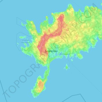
Name: Saaremaa topographic map, elevation, terrain.
Location: Saaremaa, Estonia (57.90539 21.82850 58.64229 23.32865)
Average elevation: 5 m
Minimum elevation: -1 m
Maximum elevation: 56 m
Make a donation
Gear up for your next adventure:
As an Amazon Associate, this site earns from qualifying purchases at no extra cost to you.
Other topographic maps
Click on a map to view its topography, its elevation and its terrain.