
Westleigh topographic map
Interactive map
Click on the map to display elevation.
About this map
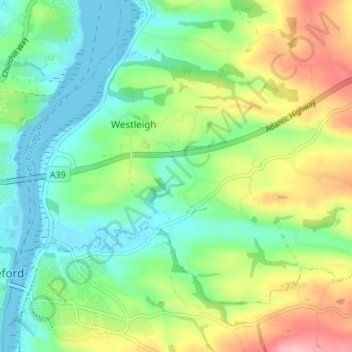
Name: Westleigh topographic map, elevation, terrain.
Location: Westleigh, North Devon, Devon, England, United Kingdom (51.01437 -4.20271 51.04524 -4.13518)
Average elevation: 49 m
Minimum elevation: -1 m
Maximum elevation: 143 m
Other topographic maps
Click on a map to view its topography, its elevation and its terrain.
Lake
United Kingdom > England > Devon > North Devon > Lake
Lake, Tawstock, North Devon, Devon, England, EX31 3HU, United Kingdom
Average elevation: 36 m