
Thank you for supporting this site ❤️
Make a donation
Make a donation
Gear up for your next adventure:
As an Amazon Associate, this site earns from qualifying purchases at no extra cost to you.
Roßtal topographic map
Click on the map to display elevation.
Thank you for supporting this site ❤️
Make a donation
Make a donation
Gear up for your next adventure:
As an Amazon Associate, this site earns from qualifying purchases at no extra cost to you.
About this map
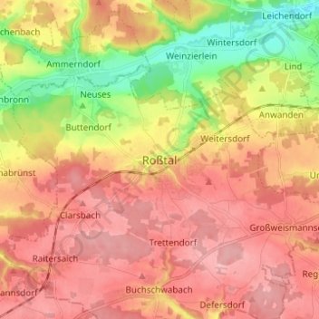
Name: Roßtal topographic map, elevation, terrain.
Location: Roßtal, Landkreis Fürth, Bayern, 90574, Deutschland (49.35779 10.84491 49.43779 10.92491)
Average elevation: 369 m
Minimum elevation: 296 m
Maximum elevation: 418 m
Thank you for supporting this site ❤️
Make a donation
Make a donation
Gear up for your next adventure:
As an Amazon Associate, this site earns from qualifying purchases at no extra cost to you.