
Thank you for supporting this site ❤️
Make a donation
Make a donation
Gear up for your next adventure:
As an Amazon Associate, this site earns from qualifying purchases at no extra cost to you.
Arak topographic map
Click on the map to display elevation.
Thank you for supporting this site ❤️
Make a donation
Make a donation
Gear up for your next adventure:
As an Amazon Associate, this site earns from qualifying purchases at no extra cost to you.
About this map
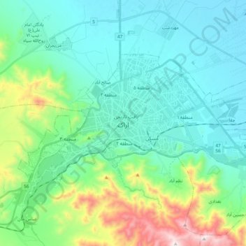
Name: Arak topographic map, elevation, terrain.
Location: Arak, بخش مرکزی, Arak County, Markazi Province, Iran (34.04294 49.60821 34.13117 49.79708)
Average elevation: 1,846 m
Minimum elevation: 1,656 m
Maximum elevation: 2,616 m
Thank you for supporting this site ❤️
Make a donation
Make a donation
Gear up for your next adventure:
As an Amazon Associate, this site earns from qualifying purchases at no extra cost to you.