
Olhão topographic map
Interactive map
Click on the map to display elevation.
About this map
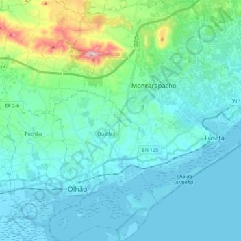
Name: Olhão topographic map, elevation, terrain.
Location: Olhão, Faro, Algarve, Portugal (36.99808 -7.88977 37.13116 -7.72336)
Average elevation: 62 m
Minimum elevation: -4 m
Maximum elevation: 408 m
Other topographic maps
Click on a map to view its topography, its elevation and its terrain.
Alcoutim
Portugal > Algarve > Alcoutim e Pereiro
Alcoutim, Alcoutim e Pereiro, ACT, Faro, Algarve, Portugal
Average elevation: 120 m
Praia da Figueira
Portugal > Algarve > Budens > Salema
Praia da Figueira, Rua 28 de Janeiro, Salema, Budens, Faro, Algarve, 8650-060, Portugal
Average elevation: 24 m
São Bartolomeu de Messines
Portugal > Algarve > São Bartolomeu de Messines
São Bartolomeu de Messines, Silves, Faro, Algarve, Portugal
Average elevation: 170 m