
Punakaiki topographic map
Interactive map
Click on the map to display elevation.
About this map
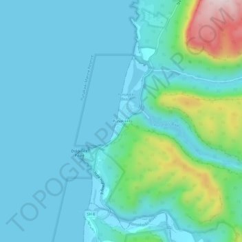
Name: Punakaiki topographic map, elevation, terrain.
Location: Punakaiki, Buller District, West Coast, 7873, New Zealand (-42.12855 171.31531 -42.08855 171.35531)
Average elevation: 70 m
Minimum elevation: 0 m
Maximum elevation: 427 m
Other topographic maps
Click on a map to view its topography, its elevation and its terrain.
Pike Peak
New Zealand > West Coast > Buller District
Pike Peak, Buller District, West Coast, New Zealand
Average elevation: 1,104 m
Mount Baldy
New Zealand > West Coast > Buller District
Mount Baldy, Buller District, West Coast, New Zealand
Average elevation: 1,059 m