
Britten topographic map
Interactive map
Click on the map to display elevation.
About this map
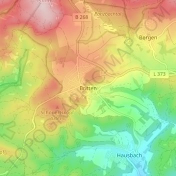
Name: Britten topographic map, elevation, terrain.
Average elevation: 367 m
Minimum elevation: 231 m
Maximum elevation: 516 m
Other topographic maps
Click on a map to view its topography, its elevation and its terrain.
Rissenthal
Deutschland > Saarland > Landkreis Merzig-Wadern > Losheim am See > Rissenthal
Rissenthal, Losheim am See, Landkreis Merzig-Wadern, Saarland, 66679, Deutschland
Average elevation: 305 m
Scheiden
Deutschland > Saarland > Landkreis Merzig-Wadern > Losheim am See > Scheiden
Scheiden, Losheim am See, Landkreis Merzig-Wadern, Saarland, 66679, Deutschland
Average elevation: 473 m
Waldhölzbach
Deutschland > Saarland > Landkreis Merzig-Wadern > Losheim am See
Waldhölzbach, Losheim am See, Landkreis Merzig-Wadern, Saarland, Deutschland
Average elevation: 440 m