Geolocate

Kilcoy topographic map

Click on the map to display elevation.

About this map

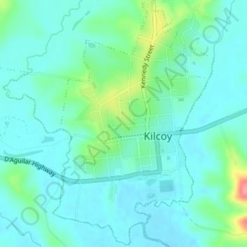
Name: Kilcoy topographic map, elevation, terrain.

Location: Kilcoy, Somerset Regional, Queensland, 4515, Australia (-26.95500 152.55264 -26.92842 152.57234)

Average elevation: 119 m

Minimum elevation: 100 m

Maximum elevation: 188 m

Queensland trails, hiking, mountain biking, running and outdoor activities

Other topographic maps

Click on a map to view its topography, its elevation and its terrain.

Kilcoy

Australia > Queensland > Kilcoy

Average elevation: 125 m

Winya

Australia > Queensland > Kilcoy > Winya

Average elevation: 126 m

Gear up for your next adventure:

📍Handheld GPS - GPS devices for hiking and navigation
📟Satellite Messengers - Two-way satellite communication to stay in touch beyond the cellular grid
📡Portable Emergency Radios - Stay informed about weather warnings and bushfire alerts
🌿Flora and Fauna Field Guides - Identify the plants and animals you encounter on your route
🔥Windproof Plasma Lighters - USB rechargeable lighters that work in high-altitude winds

As an Amazon Associate, this site earns from qualifying purchases at no extra cost to you.