
Make a donation
Gear up for your next adventure:
As an Amazon Associate, this site earns from qualifying purchases at no extra cost to you.
Cabin John topographic map
Click on the map to display elevation.
Make a donation
Gear up for your next adventure:
As an Amazon Associate, this site earns from qualifying purchases at no extra cost to you.
Cabin John
Historically, Cabin John has been part of the region known as the Potomac Gorge (Potomac Palisades), an approximately 15-mile-long (24 km) corridor or "fall zone" that sees a transition between the hard bedrock of the Piedmont to the softer rocks and soils of the Atlantic Coastal Plain and representing a drop in elevation from 140 feet (43 m) to about 10 feet (3.0 m) above sea level.
Make a donation
Gear up for your next adventure:
As an Amazon Associate, this site earns from qualifying purchases at no extra cost to you.
About this map
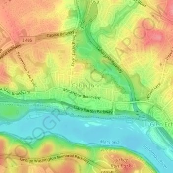
Name: Cabin John topographic map, elevation, terrain.
Average elevation: 48 m
Minimum elevation: 7 m
Maximum elevation: 90 m
Make a donation
Gear up for your next adventure:
As an Amazon Associate, this site earns from qualifying purchases at no extra cost to you.