
Mission topographic map
Click on the map to display elevation.
Mission
The western part of the district, the Stave Valley, is largely rural and forested but its watercourse is home to what was the largest hydroelectric project in British Columbia until the Bridge River Power Project opened in 1961. It was built by the British Columbia Electric Railway (BCER) to provide power to the electric street railway and interurban system in Vancouver. The Stave Falls Power Co. operated a light-gauge railway for passenger and freight service up the lower canyon of the river to the dam at Stave Falls. During the construction of the Ruskin Dam (completed 1931) the railway was rebuilt at a higher elevation so as to skirt the new Hayward Lake reservoir. The rail line has long been discontinued, but the old grade and its trestles are now part of a recreation trail circling the reservoir.
About this map
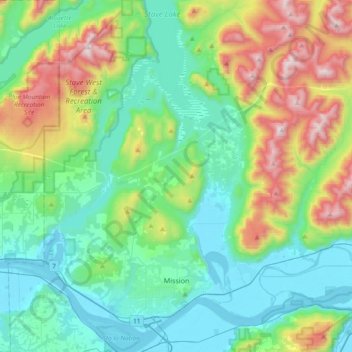
Name: Mission topographic map, elevation, terrain.
Average elevation: 345 m
Minimum elevation: -1 m
Maximum elevation: 1,329 m
Other topographic maps
Click on a map to view its topography, its elevation and its terrain.
Upper Sumas Pioneer Park
Canada > British Columbia > Fraser Valley Regional District > Abbotsford
Average elevation: 7 m
Abbotsford
Canada > British Columbia > Fraser Valley Regional District > Abbotsford
Average elevation: 115 m
Mount Hicks
Canada > British Columbia > Fraser Valley Regional District > Kent
Average elevation: 563 m