
Nuwara Eliya District topographic map
Interactive map
Click on the map to display elevation.
About this map
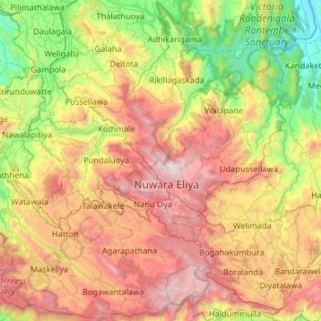
Name: Nuwara Eliya District topographic map, elevation, terrain.
Location: Nuwara Eliya District, Central Province, Sri Lanka (6.75122 80.43210 7.27393 80.96518)
Average elevation: 1,093 m
Minimum elevation: 84 m
Maximum elevation: 2,491 m
Other topographic maps
Click on a map to view its topography, its elevation and its terrain.
Ginigathhena
Ginigathhena, Nuwara Eliya District, Central Province, 20686, Sri Lanka
Average elevation: 662 m
Hatton
Hatton, Nuwara Eliya District, Central Province, 22050, Sri Lanka
Average elevation: 1,290 m
Scarborough
Sri Lanka > Central Province > Strathspey State
Scarborough, Strathspey State, Nuwara Eliya District, Central Province, Sri Lanka
Average elevation: 1,433 m
Eriyagama
Eriyagama, Kandy District, Central Province, 20400, Sri Lanka
Average elevation: 519 m
Embilmeegama
Embilmeegama, Kandy District, Central Province, 20450, Sri Lanka
Average elevation: 526 m
Nawalapitiya
Nawalapitiya, Kandy District, Central Province, 20650, Sri Lanka
Average elevation: 754 m
Kadugannawa
Kadugannawa, Kandy District, Central Province, 20300, Sri Lanka
Average elevation: 490 m
Gampola
Gampola, Kandy District, Central Province, 20500, Sri Lanka
Average elevation: 604 m
Hadunuwewa
Sri Lanka > Central Province > Kalapitiya > Hadunuwewa
Hadunuwewa, Kalapitiya, Nuwara Eliya District, Central Province, 20838, Sri Lanka
Average elevation: 836 m
Pidurutalagala
Sri Lanka > Central Province > Nuwara Eliya
Pidurutalagala, Nuwara Eliya, Nuwara Eliya District, Central Province, 22000, Sri Lanka
Average elevation: 2,264 m
Bogambara
Sri Lanka > Central Province > Kandy > Bogambara
Bogambara, Kandy, Kandy District, Central Province, 20000, Sri Lanka
Average elevation: 560 m
Queenwood
Sri Lanka > Central Province > Queenwood
Queenwood, Nuwara Eliya District, Central Province, Sri Lanka
Average elevation: 1,481 m
Glenlyon
Sri Lanka > Central Province > Glenlyon
Glenlyon, Nuwara Eliya District, Central Province, Sri Lanka
Average elevation: 1,464 m
Ehalagala
Sri Lanka > Central Province > Ehalagala
Ehalagala, Matale District, Central Province, 12120, Sri Lanka
Average elevation: 197 m
Nattarampota
Sri Lanka > Central Province > Nattarampota
Nattarampota, Kandy District, Central Province, 60622, Sri Lanka
Average elevation: 498 m
Marlborough
Sri Lanka > Central Province > Hatton
Marlborough, Hatton, Nuwara Eliya District, Central Province, Sri Lanka
Average elevation: 1,268 m