
Make a donation
Gear up for your next adventure:
As an Amazon Associate, this site earns from qualifying purchases at no extra cost to you.
Bonnechere Valley topographic map
Click on the map to display elevation.
Make a donation
Gear up for your next adventure:
As an Amazon Associate, this site earns from qualifying purchases at no extra cost to you.
About this map
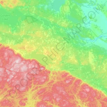
Name: Bonnechere Valley topographic map, elevation, terrain.
Average elevation: 260 m
Minimum elevation: 115 m
Maximum elevation: 519 m
Make a donation
Gear up for your next adventure:
As an Amazon Associate, this site earns from qualifying purchases at no extra cost to you.
Other topographic maps
Click on a map to view its topography, its elevation and its terrain.
Make a donation
Gear up for your next adventure:
As an Amazon Associate, this site earns from qualifying purchases at no extra cost to you.
Foymount
Canada > Ontario > Renfrew County > Bonnechere Valley
The location is also popular for amateur astronomers given the high altitude and low levels of artificial light.
Average elevation: 432 m
Palmer Rapids
Canada > Ontario > Renfrew County > Brudenell, Lyndoch and Raglan
Average elevation: 319 m
Make a donation
Gear up for your next adventure:
As an Amazon Associate, this site earns from qualifying purchases at no extra cost to you.