
Waibakul topographic map
Interactive map
Click on the map to display elevation.
About this map
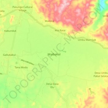
Name: Waibakul topographic map, elevation, terrain.
Location: Waibakul, Sumba Tengah, East Nusa Tenggara, Indonesia (-9.66162 119.55867 -9.58162 119.63867)
Average elevation: 447 m
Minimum elevation: 337 m
Maximum elevation: 563 m
Other topographic maps
Click on a map to view its topography, its elevation and its terrain.
Pasunga Cultural Village
Indonesia > East Nusa Tenggara > Sumba Tengah > Pasunga Cultural Village
Pasunga Cultural Village, Sumba Tengah, East Nusa Tenggara, Indonesia
Average elevation: 450 m