
Neufmarteau topographic map
Interactive map
Click on the map to display elevation.
About this map
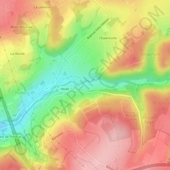
Name: Neufmarteau topographic map, elevation, terrain.
Location: Neufmarteau, Jalhay, Verviers, Liège, Wallonie, 4845, Belgique (50.53122 5.88440 50.55122 5.90440)
Average elevation: 303 m
Minimum elevation: 211 m
Maximum elevation: 373 m
Other topographic maps
Click on a map to view its topography, its elevation and its terrain.
Lac de la Gileppe
Belgique > Liège > Verviers > Jalhay
Lac de la Gileppe, Jalhay, Verviers, Liège, Wallonie, 4845, Belgique
Average elevation: 331 m
Barrage de la Gileppe
Belgique > Liège > Verviers > Jalhay
Barrage de la Gileppe, Jalhay, Baelen, Verviers, Liège, Wallonie, 4845, Belgique
Average elevation: 316 m
Baraque Michel
Belgique > Liège > Verviers > Jalhay
Baraque Michel, Jalhay, Verviers, Liège, Wallonie, 4845, Belgique
Average elevation: 652 m
La Gileppe
Belgique > Liège > Verviers > Jalhay
La Gileppe, Jalhay, Verviers, Liège, Wallonie, 4845, Belgique
Average elevation: 394 m