
Quebradas topographic map
Interactive map
Click on the map to display elevation.
About this map
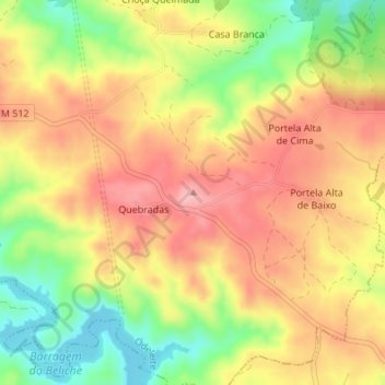
Name: Quebradas topographic map, elevation, terrain.
Location: Quebradas, Castro Marim, Faro, Portugal (37.30789 -7.51852 37.30799 -7.51842)
Average elevation: 126 m
Minimum elevation: 44 m
Maximum elevation: 190 m
Other topographic maps
Click on a map to view its topography, its elevation and its terrain.
Túnel de Descarga da Barragem de Odeleite
Portugal > Faro > Castro Marim > Odeleite
Túnel de Descarga da Barragem de Odeleite, Descarregador de Cheias da Barragem de Odeleite, Odeleite, Castro Marim, Faro, 8950-032, Portugal
Average elevation: 72 m