Geolocate

Tubod topographic map

Click on the map to display elevation.

👉 Easily get elevation data in JSON, GeoTIFF and KML formats using Elevation API
Thank you for supporting this site ❤️
Make a donation

Gear up for your next adventure:

As an Amazon Associate, this site earns from qualifying purchases at no extra cost to you.

About this map

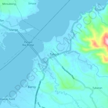
Name: Tubod topographic map, elevation, terrain.

Location: Tubod, Lanao del Norte, Northern Mindanao, 9209, Philippines (8.00866 123.75618 8.08866 123.83618)

Average elevation: 23 m

Minimum elevation: 0 m

Maximum elevation: 326 m

Other topographic maps

Click on a map to view its topography, its elevation and its terrain.

Agus River

Philippines > Lanao del Norte

Average elevation: 499 m

Linamon

Philippines > Lanao del Norte

Average elevation: 42 m

Kolambugan

Philippines > Lanao del Norte

Average elevation: 55 m

Baloi

Philippines > Lanao del Norte > Baloi

Average elevation: 393 m

Agus River

Philippines > Lanao del Norte > West Pantar

Average elevation: 536 m

Gear up for your next adventure:

🧢Outdoor Sun Hats - Sun protection hats for hiking
🧯Animal Deterrent Spray - Safety spray for wildlife
🧰Survival Kits - Essential survival gear
🥤Hydration Packs - Hydration systems for hiking
🧥Packable Rain Jackets - Breathable waterproof layers for unpredictable mountain weather

As an Amazon Associate, this site earns from qualifying purchases at no extra cost to you.