
Ogden Dunes topographic map
Interactive map
Click on the map to display elevation.
About this map
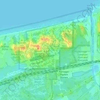
Name: Ogden Dunes topographic map, elevation, terrain.
Location: Ogden Dunes, Porter County, Indiana, United States (41.61433 -87.20288 41.63037 -87.18352)
Average elevation: 184 m
Minimum elevation: 175 m
Maximum elevation: 210 m
Other topographic maps
Click on a map to view its topography, its elevation and its terrain.
Morgan Park
United States > Indiana > Porter County > Chesterton
Morgan Park, Chesterton, Porter County, Indiana, 46304, United States
Average elevation: 197 m
Chesterton
United States > Indiana > Porter County
Chesterton, Porter County, Indiana, 46304, United States
Average elevation: 200 m
Beverly Shores
United States > Indiana > Porter County > Beverly Shores > Beverly Shores
Beverly Shores, Porter County, Indiana, 46301, United States
Average elevation: 182 m
Beverly Shores
United States > Indiana > Porter County
Beverly Shores, Porter County, Indiana, 46301, United States
Average elevation: 186 m
Valparaiso
United States > Indiana > Porter County
Valparaiso, Porter County, Indiana, 46383, United States
Average elevation: 235 m
Portage
United States > Indiana > Porter County
Portage, Porter County, Indiana, United States
Average elevation: 190 m