
Vijlen topographic map
Interactive map
Click on the map to display elevation.
About this map
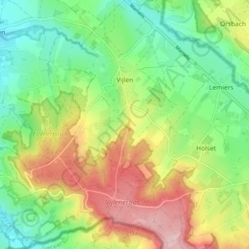
Name: Vijlen topographic map, elevation, terrain.
Location: Vijlen, Vaals, Limburg, Netherlands (50.75679 5.92054 50.80217 5.98507)
Average elevation: 190 m
Minimum elevation: 113 m
Maximum elevation: 303 m
Other topographic maps
Click on a map to view its topography, its elevation and its terrain.
Cottessen
Netherlands > Limburg > Vijlen
Cottessen, Vijlen, Vaals, Limburg, Netherlands, 6294 NE, Netherlands
Average elevation: 183 m
Vijlen
Netherlands > Limburg > Vijlen
Vijlen, Limburg, Netherlands, 6294, Netherlands
Average elevation: 180 m