
Thank you for supporting this site ❤️
Make a donation
Make a donation
Gear up for your next adventure:
As an Amazon Associate, this site earns from qualifying purchases at no extra cost to you.
Cachoeira do Sul topographic map
Click on the map to display elevation.
Thank you for supporting this site ❤️
Make a donation
Make a donation
Gear up for your next adventure:
As an Amazon Associate, this site earns from qualifying purchases at no extra cost to you.
Cachoeira do Sul
It is located at a latitude of 30º02'21" S and a longitude of 52º53'38" W, at an approximate elevation of 68 meters above sea level. Its population in 2020 was approximately 81,869 and its area is 3715.5 square kilometers.
Thank you for supporting this site ❤️
Make a donation
Make a donation
Gear up for your next adventure:
As an Amazon Associate, this site earns from qualifying purchases at no extra cost to you.
About this map
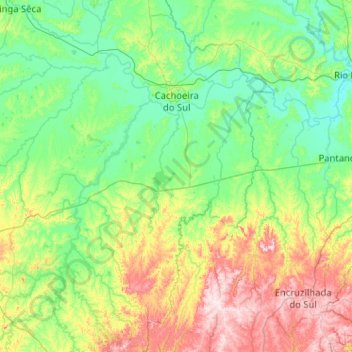
Name: Cachoeira do Sul topographic map, elevation, terrain.
Average elevation: 121 m
Minimum elevation: 4 m
Maximum elevation: 499 m
Thank you for supporting this site ❤️
Make a donation
Make a donation
Gear up for your next adventure:
As an Amazon Associate, this site earns from qualifying purchases at no extra cost to you.