
Make a donation
Gear up for your next adventure:
As an Amazon Associate, this site earns from qualifying purchases at no extra cost to you.
Plettenberg topographic map
Click on the map to display elevation.
Make a donation
Gear up for your next adventure:
As an Amazon Associate, this site earns from qualifying purchases at no extra cost to you.
Plettenberg
Plettenberg is located to the west of the Sauerland hills. The highest elevation of the town area is in the Ebbe Mountains with 663 m above sea level, the lowest elevation with 194 m near Teindeln [de]. The town is spread out between the four valleys of the rivers Lenne, Else, Oester [arz; ceb; cv; de; zh] and Grüne [ceb].
Make a donation
Gear up for your next adventure:
As an Amazon Associate, this site earns from qualifying purchases at no extra cost to you.
About this map
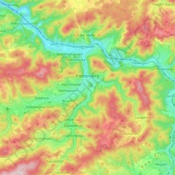
Name: Plettenberg topographic map, elevation, terrain.
Average elevation: 378 m
Minimum elevation: 186 m
Maximum elevation: 630 m
Make a donation
Gear up for your next adventure:
As an Amazon Associate, this site earns from qualifying purchases at no extra cost to you.