
Bruly topographic map
Interactive map
Click on the map to display elevation.
About this map
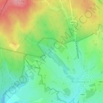
Name: Bruly topographic map, elevation, terrain.
Location: Bruly, Tintigny, Luxembourg, Wallonie, 6730, Belgique (49.71668 5.46244 49.73668 5.48244)
Average elevation: 368 m
Minimum elevation: 322 m
Maximum elevation: 438 m
Other topographic maps
Click on a map to view its topography, its elevation and its terrain.
La Breuvanne
Belgique > Wallonie > Tintigny
La Breuvanne, Tintigny, Luxembourg, Wallonie, 6730, Belgique
Average elevation: 345 m