
Make a donation
Gear up for your next adventure:
As an Amazon Associate, this site earns from qualifying purchases at no extra cost to you.
Port Matilda topographic map
Click on the map to display elevation.
Make a donation
Gear up for your next adventure:
As an Amazon Associate, this site earns from qualifying purchases at no extra cost to you.
About this map
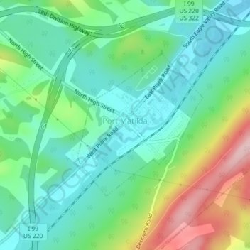
Name: Port Matilda topographic map, elevation, terrain.
Location: Port Matilda, Centre County, Pennsylvania, United States (40.79162 -78.06185 40.80784 -78.04281)
Average elevation: 359 m
Minimum elevation: 290 m
Maximum elevation: 519 m
Make a donation
Gear up for your next adventure:
As an Amazon Associate, this site earns from qualifying purchases at no extra cost to you.
Other topographic maps
Click on a map to view its topography, its elevation and its terrain.
Dalevue Park
United States > Pennsylvania > Centre County > State College > Dalevue
Average elevation: 331 m
Make a donation
Gear up for your next adventure:
As an Amazon Associate, this site earns from qualifying purchases at no extra cost to you.
Loch Lomond Junction
United States > Pennsylvania > Centre County > Rush Township
Average elevation: 460 m