
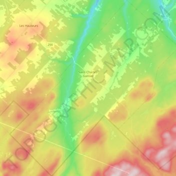
Saint-Charles-Garnier topographic map
Interactive map
Click on the map to display elevation.
About this map
Name: Saint-Charles-Garnier topographic map, elevation, terrain.
Average elevation: 334 m
Minimum elevation: 159 m
Maximum elevation: 550 m
Other topographic maps
Click on a map to view its topography, its elevation and its terrain.
Mont Comi
Canada > Quebec > La Mitis > Saint-Donat
Mont Comi, Saint-Donat, La Mitis, Bas-Saint-Laurent, Quebec, Canada
Average elevation: 420 m
Métis-sur-Mer
Métis-sur-Mer, La Mitis, Bas-Saint-Laurent, Quebec, G0J 1S0, Canada
Average elevation: 95 m
Sainte-Jeanne-d'Arc
Sainte-Jeanne-d'Arc, La Mitis, Bas-Saint-Laurent, Quebec, Canada
Average elevation: 254 m