
Make a donation
Gear up for your next adventure:
As an Amazon Associate, this site earns from qualifying purchases at no extra cost to you.
Agios Kirikos topographic map
Click on the map to display elevation.
Make a donation
Gear up for your next adventure:
As an Amazon Associate, this site earns from qualifying purchases at no extra cost to you.
About this map
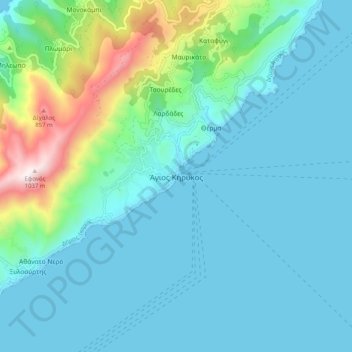
Name: Agios Kirikos topographic map, elevation, terrain.
Average elevation: 175 m
Minimum elevation: 0 m
Maximum elevation: 1,035 m
Make a donation
Gear up for your next adventure:
As an Amazon Associate, this site earns from qualifying purchases at no extra cost to you.
Other topographic maps
Click on a map to view its topography, its elevation and its terrain.
Icaria
Greece > Aegean > Ikaria Regional Unit
Ikaria is one of the middle islands of the northern Aegean, 255.303 square kilometres (98.573 sq mi) in area with 102 miles (164 kilometres) of coastline and a population of 8,312 inhabitants. The topography is a contrast between verdant slopes and barren steep rocks. The island is mountainous for the most…
Average elevation: 87 m