
Make a donation
Gear up for your next adventure:
As an Amazon Associate, this site earns from qualifying purchases at no extra cost to you.
Khetri topographic map
Click on the map to display elevation.
Make a donation
Gear up for your next adventure:
As an Amazon Associate, this site earns from qualifying purchases at no extra cost to you.
Khetri
Khetri is located at 27°59′N 75°48′E / 27.98°N 75.8°E / 27.98; 75.8. It has an average elevation of 484 metres (1587 feet). The name of the mountain in Khetri is Bhopalgarh.
Make a donation
Gear up for your next adventure:
As an Amazon Associate, this site earns from qualifying purchases at no extra cost to you.
About this map
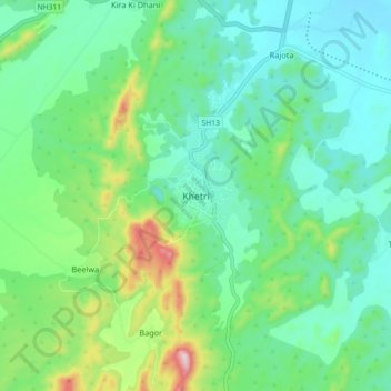
Name: Khetri topographic map, elevation, terrain.
Location: Khetri, Khetri Tehsil, Neem Ka Thana, Rajasthan, 333503, India (27.96034 75.74413 28.04034 75.82413)
Average elevation: 452 m
Minimum elevation: 353 m
Maximum elevation: 747 m
Make a donation
Gear up for your next adventure:
As an Amazon Associate, this site earns from qualifying purchases at no extra cost to you.