
Le Vallon topographic map
Interactive map
Click on the map to display elevation.
About this map
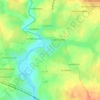
Name: Le Vallon topographic map, elevation, terrain.
Average elevation: 68 m
Minimum elevation: 45 m
Maximum elevation: 91 m
Other topographic maps
Click on a map to view its topography, its elevation and its terrain.
La Forêt
France > Pays de la Loire > Val-du-Maine
La Forêt, Épineux-le-Seguin, Val-du-Maine, Château-Gontier, Mayenne, Pays de la Loire, France métropolitaine, 53340, France
Average elevation: 79 m