
Thank you for supporting this site ❤️
Make a donation
Make a donation
Gear up for your next adventure:
As an Amazon Associate, this site earns from qualifying purchases at no extra cost to you.
Sarlande topographic map
Click on the map to display elevation.
Thank you for supporting this site ❤️
Make a donation
Make a donation
Gear up for your next adventure:
As an Amazon Associate, this site earns from qualifying purchases at no extra cost to you.
About this map
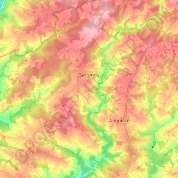
Name: Sarlande topographic map, elevation, terrain.
Average elevation: 321 m
Minimum elevation: 220 m
Maximum elevation: 390 m
Thank you for supporting this site ❤️
Make a donation
Make a donation
Gear up for your next adventure:
As an Amazon Associate, this site earns from qualifying purchases at no extra cost to you.
Other topographic maps
Click on a map to view its topography, its elevation and its terrain.
La Fageole
France > Nouvelle-Aquitaine > Dordogne > Saint-Félix-de-Reillac-et-Mortemart
Average elevation: 213 m
Laudibertie
France > Nouvelle-Aquitaine > Dordogne > Saint-Privat-en-Périgord > Festalemps
Average elevation: 93 m