
Make a donation
Gear up for your next adventure:
As an Amazon Associate, this site earns from qualifying purchases at no extra cost to you.
Alta Sierra topographic map
Click on the map to display elevation.
Make a donation
Gear up for your next adventure:
As an Amazon Associate, this site earns from qualifying purchases at no extra cost to you.
Alta Sierra
Alta Sierra was laid out by property developers in the 1960s. Alta Sierra is a golf course community, with homes built around the Alta Sierra Country Club, a semi-private 18 hole course built in 1964. The community has a member-owned airport with a 2800-foot runway. The community is located just east of California State Highway 49, at an elevation of approximately 2300 feet, between the cities of Grass Valley, California to the north and Auburn, California to the south. There is a small commercial district with several restaurants, a gas station, a market and personal service businesses. There is also an elementary school and a motel.
Make a donation
Gear up for your next adventure:
As an Amazon Associate, this site earns from qualifying purchases at no extra cost to you.
About this map
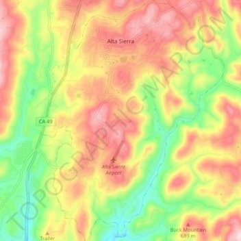
Name: Alta Sierra topographic map, elevation, terrain.
Location: Alta Sierra, Nevada County, California, United States (39.08918 -121.08055 39.15229 -121.01878)
Average elevation: 603 m
Minimum elevation: 449 m
Maximum elevation: 780 m
Make a donation
Gear up for your next adventure:
As an Amazon Associate, this site earns from qualifying purchases at no extra cost to you.