
Iris topographic map
Click on the map to display elevation.
About this map
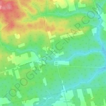
Name: Iris topographic map, elevation, terrain.
Location: Iris, Queens County, Prince Edward Island, Canada (45.99671 -62.73102 46.03830 -62.68487)
Average elevation: 41 m
Minimum elevation: 6 m
Maximum elevation: 98 m
Other topographic maps
Click on a map to view its topography, its elevation and its terrain.
French Village
Canada > Prince Edward Island > Queens County > Savage Harbour, Queen's County
Average elevation: 12 m