
Thank you for supporting this site ❤️
Make a donation
Make a donation
Gear up for your next adventure:
As an Amazon Associate, this site earns from qualifying purchases at no extra cost to you.
Innisfil topographic map
Click on the map to display elevation.
Thank you for supporting this site ❤️
Make a donation
Make a donation
Gear up for your next adventure:
As an Amazon Associate, this site earns from qualifying purchases at no extra cost to you.
About this map
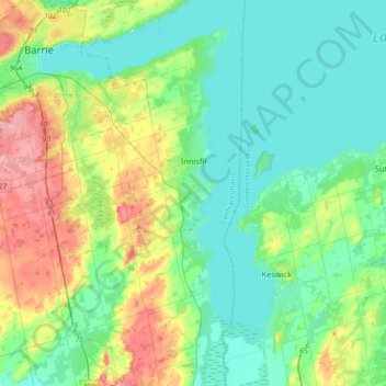
Name: Innisfil topographic map, elevation, terrain.
Location: Innisfil, Simcoe County, Central Ontario, Ontario, Canada (44.16502 -79.72791 44.42224 -79.49800)
Average elevation: 243 m
Minimum elevation: 213 m
Maximum elevation: 322 m
Thank you for supporting this site ❤️
Make a donation
Make a donation
Gear up for your next adventure:
As an Amazon Associate, this site earns from qualifying purchases at no extra cost to you.