
Make a donation
Gear up for your next adventure:
As an Amazon Associate, this site earns from qualifying purchases at no extra cost to you.
Mittelbuchen topographic map
Click on the map to display elevation.
Make a donation
Gear up for your next adventure:
As an Amazon Associate, this site earns from qualifying purchases at no extra cost to you.
Mittelbuchen
Mittelbuchen liegt auf einer Höhe von 116 m über NN und ist der nördlichste Stadtteil von Hanau, 5,5 km nordwestlich der Kernstadt gelegen und von dieser durch einen Forst getrennt. Die Stadt Frankfurt am Main liegt etwa 17 Kilometer westlich. Die nächstgelegenen Orte sind im Westen der Stadtteil Wachenbuchen der Stadt Maintal und im Osten Bruchköbel, jeweils nur wenige Kilometer entfernt. Etwa drei Kilometer nordwestlich liegt, getrennt durch den Höhenrücken der „Hohen Straße“, Kilianstädten.
Make a donation
Gear up for your next adventure:
As an Amazon Associate, this site earns from qualifying purchases at no extra cost to you.
About this map
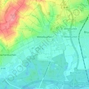
Name: Mittelbuchen topographic map, elevation, terrain.
Location: Mittelbuchen, Hanau, Main-Kinzig-Kreis, Hessen, Deutschland (50.15216 8.86198 50.19551 8.90892)
Average elevation: 127 m
Minimum elevation: 103 m
Maximum elevation: 191 m
Make a donation
Gear up for your next adventure:
As an Amazon Associate, this site earns from qualifying purchases at no extra cost to you.