
Durango topographic map
Click on the map to display elevation.
Durango
Durango is set within a striking and diverse topography characterized by its elevation of 6,512 feet above sea level and its position in the Animas River Valley. The city lies at the foothills of the rugged La Plata Mountains to the west and is flanked by the San Juan Mountains to the north and east. This mountainous terrain features numerous peaks over 14,000 feet, along with other high summits and vast wilderness areas, providing dramatic landscapes and opportunities for outdoor recreation. The surrounding geography is marked by steep slopes, deep canyons, and the flowing Animas River, which carves through the landscape, contributing to the area's natural beauty and ecological diversity. The terrain not only shapes the local climate but also plays a significant role in the outdoor activities that draw visitors year-round, from hiking and skiing to mountain biking.
About this map
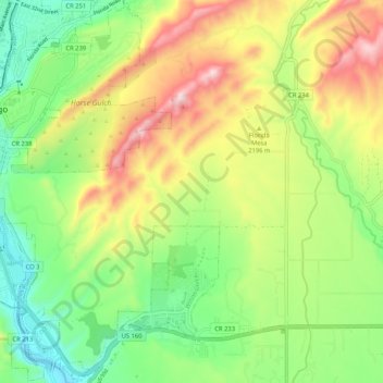
Name: Durango topographic map, elevation, terrain.
Location: Durango, La Plata County, Colorado, United States (37.21797 -107.93729 37.32670 -107.81391)
Average elevation: 2,162 m
Minimum elevation: 1,939 m
Maximum elevation: 2,638 m
Other topographic maps
Click on a map to view its topography, its elevation and its terrain.
Durango
United States > Colorado > La Plata County > Durango
Durango is located at 37°16′N 107°52′W / 37.267°N 107.867°W / 37.267; -107.867 at an elevation of 6,512 ft (1,988 m). At the 2020 United States Census, the town had a total area of 10,946 acres (44.296 km2) including 1,533 acres (6.203 km2) of water.
Average elevation: 2,360 m