
Бия topographic map
Interactive map
Click on the map to display elevation.
About this map
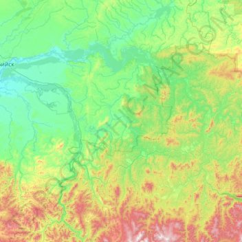
Name: Бия topographic map, elevation, terrain.
Average elevation: 486 m
Minimum elevation: 164 m
Maximum elevation: 2,028 m
Other topographic maps
Click on a map to view its topography, its elevation and its terrain.
Амелин
Russie > Kraï de l'Altaï > Сибирячихинский сельсовет
Амелин, Сибирячихинский сельсовет, Солонешенский район, Kraï de l'Altaï, District fédéral sibérien, Russie
Average elevation: 607 m