Geolocate

Odesa topographic map

Click on the map to display elevation.

About this map

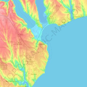
Name: Odesa topographic map, elevation, terrain.

Location: Odesa, Prymors'kyi Rayon, Odesa, Odesa Oblast, 65026, Ukraine (46.32732 30.57928 46.64732 30.89928)

Average elevation: 26 m

Minimum elevation: -9 m

Maximum elevation: 86 m

Other topographic maps

Click on a map to view its topography, its elevation and its terrain.

Kyivskyi Raion

Ukraine > Odesa Oblast > Odesa

Average elevation: 29 m

Kyivskyi Raion

Ukraine > Odesa Oblast > Odesa

Average elevation: 29 m

Prymorskyi Raion

Ukraine > Odesa Oblast > Odesa

Average elevation: 26 m

Prymorskyi Raion

Ukraine > Odesa Oblast > Odesa

Average elevation: 26 m

Gear up for your next adventure:

Altimeter Barometer Watches - Outdoor watches with built-in sensors to track altitude changes and weather shifts
🎒Hiking Backpacks - Backpacks designed for hiking and trekking
🦶Orthotic Hiking Insoles - Extra arch support for long-distance topographic treks
🦘Outback Survival Gear - Essential gear for Australian outback
🆘Personal Locator Beacons (PLB) - Satellite emergency beacons for life-saving help in areas with no mobile coverage

As an Amazon Associate, this site earns from qualifying purchases at no extra cost to you.