
Make a donation
Gear up for your next adventure:
As an Amazon Associate, this site earns from qualifying purchases at no extra cost to you.
Schierling topographic map
Click on the map to display elevation.
Make a donation
Gear up for your next adventure:
As an Amazon Associate, this site earns from qualifying purchases at no extra cost to you.
Schierling
Am 22. April 1809 besiegte Napoleon mit seinen Verbündeten Österreich in der „Schlacht bei Eggmühl“ entscheidend. Diese Schlacht in der Laberaue und auf den angrenzenden Höhen wurde von Napoleon später als seine größte Bewährungsprobe bezeichnet. Seit 1909 steht ein Löwendenkmal, mahnend an die Tausende von Opfern, über dem ehemaligen Schlachtfeld.
Make a donation
Gear up for your next adventure:
As an Amazon Associate, this site earns from qualifying purchases at no extra cost to you.
About this map
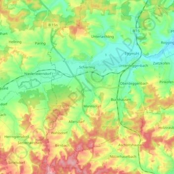
Name: Schierling topographic map, elevation, terrain.
Location: Schierling, Landkreis Regensburg, Bayern, 84069, Deutschland (48.76491 12.09690 48.87883 12.25965)
Average elevation: 411 m
Minimum elevation: 358 m
Maximum elevation: 493 m
Make a donation
Gear up for your next adventure:
As an Amazon Associate, this site earns from qualifying purchases at no extra cost to you.
Other topographic maps
Click on a map to view its topography, its elevation and its terrain.
Make a donation
Gear up for your next adventure:
As an Amazon Associate, this site earns from qualifying purchases at no extra cost to you.
Make a donation
Gear up for your next adventure:
As an Amazon Associate, this site earns from qualifying purchases at no extra cost to you.
Make a donation
Gear up for your next adventure:
As an Amazon Associate, this site earns from qualifying purchases at no extra cost to you.
Hainsacker
Deutschland > Bayern > Landkreis Regensburg
Altenried | Aschach | Baiern | Benhof | Einhausen | Geiersberg | Gewald | Hainsacker | Harreshof | Hohensand | Hönighausen | Kareth | Kaulhausen | Knieschlag | Landlhof | Lappersdorf | Lorenzen | Oppersdorf | Pielmühle | Rehthal | Rodau | Schinderwies | Schwaighausen | Schwärz | Schwerdnermühle | Steinhof…
Average elevation: 402 m
Make a donation
Gear up for your next adventure:
As an Amazon Associate, this site earns from qualifying purchases at no extra cost to you.
Wörth an der Donau
Deutschland > Bayern > Landkreis Regensburg > Wörth an der Donau > Wörth an der Donau
Average elevation: 379 m
Make a donation
Gear up for your next adventure:
As an Amazon Associate, this site earns from qualifying purchases at no extra cost to you.
Wichenbach
Deutschland > Bayern > Landkreis Regensburg > Wörth an der Donau > Tiefenthal
Average elevation: 376 m
Make a donation
Gear up for your next adventure:
As an Amazon Associate, this site earns from qualifying purchases at no extra cost to you.
Make a donation
Gear up for your next adventure:
As an Amazon Associate, this site earns from qualifying purchases at no extra cost to you.
Make a donation
Gear up for your next adventure:
As an Amazon Associate, this site earns from qualifying purchases at no extra cost to you.
Make a donation
Gear up for your next adventure:
As an Amazon Associate, this site earns from qualifying purchases at no extra cost to you.
Make a donation
Gear up for your next adventure:
As an Amazon Associate, this site earns from qualifying purchases at no extra cost to you.
Make a donation
Gear up for your next adventure:
As an Amazon Associate, this site earns from qualifying purchases at no extra cost to you.
Make a donation
Gear up for your next adventure:
As an Amazon Associate, this site earns from qualifying purchases at no extra cost to you.
Make a donation
Gear up for your next adventure:
As an Amazon Associate, this site earns from qualifying purchases at no extra cost to you.
Danersdorf
Deutschland > Bayern > Landkreis Regensburg > Regenstauf > Gnadenhof
Average elevation: 482 m
Make a donation
Gear up for your next adventure:
As an Amazon Associate, this site earns from qualifying purchases at no extra cost to you.
Wenzenbach
Deutschland > Bayern > Landkreis Regensburg > Probstberg > Zeitlhof
Average elevation: 389 m
Holzheim am Forst
Deutschland > Bayern > Landkreis Regensburg > Holzheim am Forst > Holzheim am Forst
Average elevation: 391 m
Make a donation
Gear up for your next adventure:
As an Amazon Associate, this site earns from qualifying purchases at no extra cost to you.
Kollersried
Deutschland > Bayern > Landkreis Regensburg > Hemau > Laufenthal > Kollersried
Average elevation: 501 m
Neuhaus
Deutschland > Bayern > Landkreis Regensburg > Regenstauf > Diesenbach
Average elevation: 365 m
Make a donation
Gear up for your next adventure:
As an Amazon Associate, this site earns from qualifying purchases at no extra cost to you.
Make a donation
Gear up for your next adventure:
As an Amazon Associate, this site earns from qualifying purchases at no extra cost to you.