Geolocate

North Adelaide topographic map

Click on the map to display elevation.

About this map

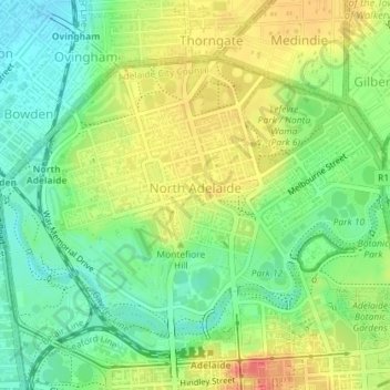
Name: North Adelaide topographic map, elevation, terrain.

Location: North Adelaide, Adelaide, Adelaide City Council, South Australia, 5006, Australia (-34.91949 138.57702 -34.89861 138.61290)

Average elevation: 40 m

Minimum elevation: 15 m

Maximum elevation: 70 m

Adelaide City Council trails, hiking, mountain biking, running and outdoor activities

👉 Easily get elevation data in JSON, GeoTIFF and KML formats using Elevation API
Thank you for supporting this site ❤️
Make a donation

Gear up for your next adventure:

As an Amazon Associate, this site earns from qualifying purchases at no extra cost to you.

Other topographic maps

Click on a map to view its topography, its elevation and its terrain.

Gear up for your next adventure:

📍Handheld GPS - GPS devices for hiking and navigation
📟Satellite Messengers - Two-way satellite communication to stay in touch beyond the cellular grid
🦯Adjustable Trekking Poles - Reduce impact on knees when descending steep topographic ridges
🥤Outdoor Water Bottles - Reusable bottles for outdoor activities
🩹Blister Prevention Tape - Apply to friction points before they become painful sores

As an Amazon Associate, this site earns from qualifying purchases at no extra cost to you.