
Make a donation
Gear up for your next adventure:
As an Amazon Associate, this site earns from qualifying purchases at no extra cost to you.
West Kelowna topographic map
Click on the map to display elevation.
Make a donation
Gear up for your next adventure:
As an Amazon Associate, this site earns from qualifying purchases at no extra cost to you.
About this map
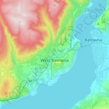
Name: West Kelowna topographic map, elevation, terrain.
Average elevation: 649 m
Minimum elevation: 335 m
Maximum elevation: 1,539 m
Make a donation
Gear up for your next adventure:
As an Amazon Associate, this site earns from qualifying purchases at no extra cost to you.
Other topographic maps
Click on a map to view its topography, its elevation and its terrain.
The Commons Field
Canada > British Columbia > Regional District of Central Okanagan > Kelowna
Average elevation: 442 m
Fintry
Canada > British Columbia > Regional District of Central Okanagan > West Central Okanagan Electoral Area
Average elevation: 437 m
Pandosy
Canada > British Columbia > Regional District of Central Okanagan > Kelowna
Average elevation: 345 m
Terrace Mountain
Canada > British Columbia > Regional District of Central Okanagan > West Central Okanagan Electoral Area
Average elevation: 1,553 m
Make a donation
Gear up for your next adventure:
As an Amazon Associate, this site earns from qualifying purchases at no extra cost to you.
Mission Creek Regional Park
Canada > British Columbia > Regional District of Central Okanagan > Kelowna
Average elevation: 436 m
Oyama
Canada > British Columbia > Regional District of Central Okanagan > Lake Country
Average elevation: 481 m
Lake Country
Canada > British Columbia > Regional District of Central Okanagan > Lake Country > Lake Country
Average elevation: 528 m
West Kelowna
Canada > British Columbia > Regional District of Central Okanagan > West Kelowna
Average elevation: 871 m
Make a donation
Gear up for your next adventure:
As an Amazon Associate, this site earns from qualifying purchases at no extra cost to you.
Damer Lake
Canada > British Columbia > Regional District of Central Okanagan > East Central Okanagan Electoral Area
Average elevation: 1,353 m
Browne Lake
Canada > British Columbia > Regional District of Central Okanagan > East Central Okanagan Electoral Area
Average elevation: 1,326 m
Christie Lake
Canada > British Columbia > Regional District of Central Okanagan > West Central Okanagan Electoral Area
Average elevation: 1,448 m
Little White Mountain
Canada > British Columbia > Regional District of Central Okanagan > East Central Okanagan Electoral Area
Average elevation: 1,935 m
Make a donation
Gear up for your next adventure:
As an Amazon Associate, this site earns from qualifying purchases at no extra cost to you.
Black Knight Mountain
Canada > British Columbia > Regional District of Central Okanagan > East Central Okanagan Electoral Area
Average elevation: 992 m
Moraine Park
Canada > British Columbia > Regional District of Central Okanagan > Kelowna
Average elevation: 408 m
Oyama
Canada > British Columbia > Regional District of Central Okanagan > Lake Country
Average elevation: 481 m
Moraine Park
Canada > British Columbia > Regional District of Central Okanagan > Kelowna
Average elevation: 408 m
Make a donation
Gear up for your next adventure:
As an Amazon Associate, this site earns from qualifying purchases at no extra cost to you.