Geolocate

Manston topographic map

Click on the map to display elevation.

About this map

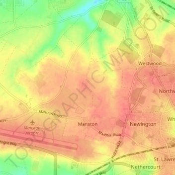
Name: Manston topographic map, elevation, terrain.

Location: Manston, Thanet, Kent, England, United Kingdom (51.33609 1.32323 51.37412 1.39293)

Average elevation: 39 m

Minimum elevation: 5 m

Maximum elevation: 56 m

Other topographic maps

Click on a map to view its topography, its elevation and its terrain.

Ebbsfleet

United Kingdom > England > Kent > Thanet

Average elevation: 4 m

Broadstairs

United Kingdom > England > Kent > Thanet

Average elevation: 14 m

Minnis Bay

United Kingdom > England > Kent > Thanet

Average elevation: 6 m

Dane Park

United Kingdom > England > Kent > Thanet > Margate

Average elevation: 18 m

Haine

United Kingdom > England > Kent > Thanet > Ramsgate > Westwood

Average elevation: 42 m

Weatherlees Hill

United Kingdom > England > Kent > Thanet > Ebbsfleet

Average elevation: 4 m

Hoo

United Kingdom > England > Kent > Thanet > Minster

Average elevation: 16 m

Pegwell Bay

United Kingdom > England > Kent > Thanet > Cliffsend

Average elevation: 9 m

Flete

United Kingdom > England > Kent > Thanet > Manston

Average elevation: 39 m

Ebbsfleet

United Kingdom > England > Kent > Thanet

Average elevation: 4 m

Broadstairs

United Kingdom > England > Kent > Thanet

Average elevation: 14 m

Way

United Kingdom > England > Kent > Thanet > Minster > Way

Average elevation: 23 m

Gear up for your next adventure:

🧥Down Jackets - Insulated jackets for cold weather
🕶️Polarized Outdoor Sunglasses - Reduce glare from rocks and water for better visual navigation
🔥Ferrocerium Rod Fire Starters - Reliable fire lighting in wet or windy conditions without matches
🎒Daypacks - Compact backpacks for short hikes
🧺Fast-Dry Microfiber Towels - Large towels that pack down to the size of an orange

As an Amazon Associate, this site earns from qualifying purchases at no extra cost to you.