
Make a donation
Gear up for your next adventure:
As an Amazon Associate, this site earns from qualifying purchases at no extra cost to you.
Albany topographic map
Click on the map to display elevation.
Make a donation
Gear up for your next adventure:
As an Amazon Associate, this site earns from qualifying purchases at no extra cost to you.
Albany
According to the United States Census Bureau, the town has a total area of 75.8 square miles (196.2 km2), of which 75.1 square miles (194.6 km2) are land and 0.58 square miles (1.5 km2) are water, comprising 0.79% of the town. It is drained by the Swift River in the north and the Chocorua River in the south. The town lies fully within the Saco River watershed. Mount Chocorua, the highest point in Albany, has an elevation of 3,474 feet (1,059 m), and Mount Paugus has an elevation of 3,201 ft (976 m).
Make a donation
Gear up for your next adventure:
As an Amazon Associate, this site earns from qualifying purchases at no extra cost to you.
About this map
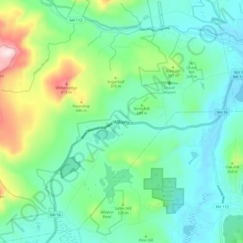
Name: Albany topographic map, elevation, terrain.
Location: Albany, Carroll County, New Hampshire, United States (43.91998 -71.23296 43.99998 -71.15296)
Average elevation: 276 m
Minimum elevation: 136 m
Maximum elevation: 709 m
Make a donation
Gear up for your next adventure:
As an Amazon Associate, this site earns from qualifying purchases at no extra cost to you.
Other topographic maps
Click on a map to view its topography, its elevation and its terrain.