
Alausí topographic map
Interactive map
Click on the map to display elevation.
About this map
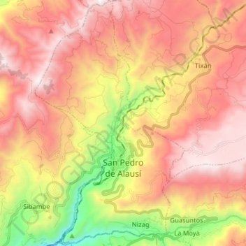
Name: Alausí topographic map, elevation, terrain.
Location: Alausí, Chimborazo, Équateur (-2.24600 -78.89156 -2.11733 -78.81325)
Average elevation: 2,938 m
Minimum elevation: 1,817 m
Maximum elevation: 3,774 m
Other topographic maps
Click on a map to view its topography, its elevation and its terrain.
Ajus Pucara
Équateur > Chimborazo > Alausí > Achupallas
Ajus Pucara, Achupallas, Alausí, Chimborazo, Équateur
Average elevation: 3,444 m