
Goddard topographic map
Click on the map to display elevation.
Goddard
Goddard is located at 37°39′35″N 97°34′27″W / 37.65972°N 97.57417°W / 37.65972; -97.57417 (37.659706, -97.574271) at an elevation of 1,463 feet (446 m). Goddard lies on U.S. Route 54 in south-central Kansas, immediately west of Wichita.
About this map
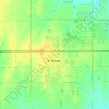
Name: Goddard topographic map, elevation, terrain.
Location: Goddard, Sedgwick County, Kansas, United States (37.64312 -97.59830 37.68582 -97.53479)
Average elevation: 443 m
Minimum elevation: 429 m
Maximum elevation: 455 m
Other topographic maps
Click on a map to view its topography, its elevation and its terrain.