
Thank you for supporting this site ❤️
Make a donation
Make a donation
Gear up for your next adventure:
🐍Australian Snake Bite Kits - Specific pressure immobilization bandages for Australian venomous snakes
🆘Personal Locator Beacons (PLB) - Satellite emergency beacons for life-saving help in areas with no mobile coverage
As an Amazon Associate, this site earns from qualifying purchases at no extra cost to you.
Reinhardt topographic map
Click on the map to display elevation.
Thank you for supporting this site ❤️
Make a donation
Make a donation
Gear up for your next adventure:
As an Amazon Associate, this site earns from qualifying purchases at no extra cost to you.
About this map
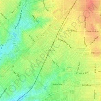
Name: Reinhardt topographic map, elevation, terrain.
Average elevation: 164 m
Minimum elevation: 138 m
Maximum elevation: 187 m
Thank you for supporting this site ❤️
Make a donation
Make a donation
Gear up for your next adventure:
As an Amazon Associate, this site earns from qualifying purchases at no extra cost to you.
Other topographic maps
Click on a map to view its topography, its elevation and its terrain.
Klyde Warren Park-Arts District PID
United States > Texas > Dallas County > Dallas
Average elevation: 143 m
Thank you for supporting this site ❤️
Make a donation
Make a donation
Gear up for your next adventure:
As an Amazon Associate, this site earns from qualifying purchases at no extra cost to you.