
Make a donation
Gear up for your next adventure:
As an Amazon Associate, this site earns from qualifying purchases at no extra cost to you.
Reforma topographic map
Click on the map to display elevation.
Make a donation
Gear up for your next adventure:
As an Amazon Associate, this site earns from qualifying purchases at no extra cost to you.
About this map
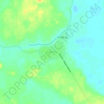
Name: Reforma topographic map, elevation, terrain.
Location: Reforma, Bacalar, Quintana Roo, México (18.79316 -88.59268 18.83316 -88.55268)
Average elevation: 21 m
Minimum elevation: 10 m
Maximum elevation: 40 m
Make a donation
Gear up for your next adventure:
As an Amazon Associate, this site earns from qualifying purchases at no extra cost to you.
Other topographic maps
Click on a map to view its topography, its elevation and its terrain.
Bacalar
México > Quintana Roo > Bacalar
Bacalar está situada en el sur del estado de Quintana Roo y a una altitud de 10 metros sobre el nivel del mar, se encuentra a una distancia aproximada de 45 kilómetros al norte de la ciudad de Chetumal con la que une la Carretera Federal 307 que entre Bacalar y Chetumal es una autopista de cuatro carriles,…
Average elevation: 8 m