
Tarente topographic map
Interactive map
Click on the map to display elevation.
About this map
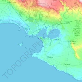
Name: Tarente topographic map, elevation, terrain.
Location: Tarente, Taranto, Pouilles, Italie (40.33000 17.11655 40.59152 17.47272)
Average elevation: 41 m
Minimum elevation: -3 m
Maximum elevation: 301 m
Other topographic maps
Click on a map to view its topography, its elevation and its terrain.
Martina Franca
Martina Franca, Taranto, Pouilles, 74015, Italie
Average elevation: 341 m
Grottaglie
Grottaglie, Taranto, Pouilles, 74023, Italie
Average elevation: 141 m