
Make a donation
Gear up for your next adventure:
As an Amazon Associate, this site earns from qualifying purchases at no extra cost to you.
Betlis topographic map
Click on the map to display elevation.
Make a donation
Gear up for your next adventure:
As an Amazon Associate, this site earns from qualifying purchases at no extra cost to you.
About this map
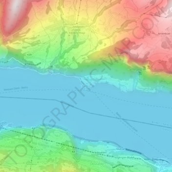
Name: Betlis topographic map, elevation, terrain.
Average elevation: 716 m
Minimum elevation: 416 m
Maximum elevation: 1,401 m
Make a donation
Gear up for your next adventure:
As an Amazon Associate, this site earns from qualifying purchases at no extra cost to you.
Other topographic maps
Click on a map to view its topography, its elevation and its terrain.
Benken (SG)
Switzerland > St. Gallen > Wahlkreis See-Gaster
The municipality is located in the See-Gaster Wahlkreis (constituency) along the Linth river. The topography of the land has changed drastically in the past centuries. During the Middle Ages the village was along the swampy, winding river. Following the Linth river control project in 1807-23 and the…
Average elevation: 427 m
Make a donation
Gear up for your next adventure:
As an Amazon Associate, this site earns from qualifying purchases at no extra cost to you.